


AviNavi, navigation for pilots

Beschreibung von AviNavi, navigation for pilots
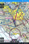
Luftfahrtnavigation einfach und erschwinglich gemacht. Alle VFR-, IFR- und Instrumentenanflugkarten für die kontinentalen Vereinigten Staaten mit vollständiger Flugplanung, einschließlich Unterstützung für die Flugnavigation. Overlays für Nexrad, METARs und AIRMETS/SIGMETS verbessern die Flugsicherheit und detaillierte Flughafeninformationen (Landebahnen, Frequenzen, Treibstoff, Wetter) stehen Ihnen zur Verfügung.
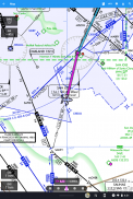
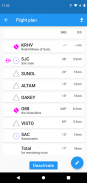
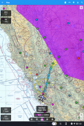
Verwenden Sie die Moving Map, um einen Flughafen, VOR, NDB oder eine Kreuzung zu suchen oder auszuwählen und die Direktnavigation zu starten oder zum Flugplan hinzuzufügen. Alternativ geben Sie den Flugplan in Text ein, z.B. KPAO SUNOL V334 SAC KSAC lädt den vollständigen Flugplan, einschließlich aller Flugliniennavigationspunkte.
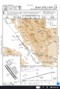
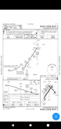
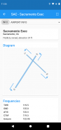
Instrumentenanflugkarten enthalten das Flughafendiagramm, STARS, DPs und Minimum sowie die Legende.
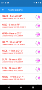
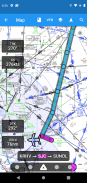
In der Nähe befindliche Flughäfen werden in Grün oder Rot angezeigt, um anzuzeigen, ob diese Flughäfen bei einem Gleitflug ohne Wind wahrscheinlich erreichbar sind oder nicht.
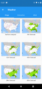
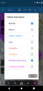
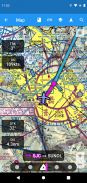
METAR, TAF, AIRMET, SIGMET, Prog charts, Convective Outlook und Wind stehen als grafische und/oder textuelle Informationen zur Verfügung. METARs und AIRMETS/SIGMETS können mit der Schaltfläche Layers auf der Karte überlagert werden. Flughafeninformationen zeigen METARs und TAFs in Klartext, und Prog-Charts, Convective Outlook und Wind-Grafiken für verschiedene Zeiten und Höhen sind als Vollbildgrafiken verfügbar.
AviNavi erfordert nach einer kostenlosen Testphase ein monatliches oder jährliches Abonnement.
AviNavi, navigation for pilots – Version 4.5.7
(08-01-2024)
AviNavi, navigation for pilots – APK Informationen
APK Version: 4.5.7Paket: com.bbflight.avinaviNeueste Version von AviNavi, navigation for pilots
Weitere Versionen


Apps in derselben Kategorie

Das könnte dir auch gefallen...


